Google Earth and Google Maps both support adding markers to their maps, but only Google Earth supports having folders of markers. Since we have folders, you must use Google Earth. Google lets you create a file called a KML file that contains the information of what markers to display and where to place them on the map using a “language” called Keyhole Markup Language (KML).
We created a KLM file called VAMaster with 4 folders in it. One for each of the following: Repeaters in Virginia (2 meters and 70 CM), VA Hams (All Hams in Virginia), RARC members, and the 6 Meter Club members. Each folder’s contents are visible (plotted on the map) or invisible (not on the map), default is invisible.
Do to the number of hams in Virginia, the VA Hams folder has a sub folder for each level of licenses – VA Hams Novice, VA Hams Technician, VA Hams General, VA Hams Advance, VA Hams Extra, and lastly VA Hams Clubs. Since a club’s call sign doesn’t have a license level, the marker is a pink color and has no letter in it. You can select all hams by checking the VA Hams folder, or select only the license level of the hams you are interested in. Due to the large number of hams in Virginia, please have you viewing height below 150 miles before selection the VA Hams folder for viewing. Otherwise when your computer tries to plot all of the points it is likely to hang or crash. It is something to “play” with and see how your computer behaves.
The folders places a tear drop on the earth where Hams live or a repeater is located. The repeaters are limited to only active and open repeaters in Virginia. The first folder has the repeaters in it, then the hams in the Virginia, Members of the RARC and Members of the 6 Meter Club.
Comments on how to use the KML file:
- The comments after the VA Master heading tells you when the file was created.
- Clicking the box before a group checks all of the boxes for each ham or repeater in the group – on (visible) or off (invisible).
- Many members of the two clubs, 6 Meter and RARC, are the same people and most club members are in Virginia so having more than on group visible can causes two or 3 markers to be placed at the same location. Both clubs have members that live outside of outside Virginia.
- For Hams, the letter in the marker is the level of the license (E,A,G,T,N) a blank is a club’s license. For a repeater there is a number 2 or 7 (2 meter or 70 centimeters)
- Clicking on the name takes you to QRZ where you can look up the person. The first time you go to QRZ, from a Google Earth session you will need to logon. There is a < < Back to Google Earth area at the top left of the QRZ area.
How to find a Ham when you know their call sign
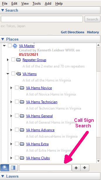
There are two places where you can do searches in Google Earth. One at the top left that has an arrow pointing down and the word Search. The second one is at the end of the Places section (see picture to the left and the Red arrow). It has the magnifying glass then a box (or disk drive) and a space to enter the search field. That is where you can place a Call Sign of a ham which is then highlighted in the list of hams. There is a box before the call sign that when checked, allows the tear drop to be placed on the map. Clicking in the highlighted area takes you to the place.
It is easy to start using the file, download below and save it some place on your PC. The file you download has the extension of KMZ not KML. The KMZ is just the compressed version of the KLM file. Otherwise it would be quite large. Double click on it and if Google Earth is installed it will open it and load the KMZ file in Temporary Places in Google Earth. When you exit Google Earth will ask if you would like to move it to My places. Select yes and you will then have the file as part of Google Earth forever. To remove it, say a new release, right click on the VA Master group and from the drop-down box, select Delete and it is gone. Then exit Google Earth and then Double click on newly downloaded version.
You can download the VA Master.KMZ file here
Current file is as of 04/06/2026